Multiple Opening Analysis
Did you know that if you have a bridge opening and one or more culverts at a single river crossing a Multiple Opening Analysis is required?
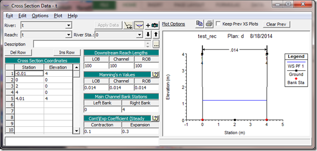
Many water surface profile software programs prior to HEC-RAS had a quirky rule against having perfect vertical sides. In other words, you could not have two or more elevations at the same stationing. A perfect example of this is a rectangular flume. The workaround for the older software was to define the tops of the flume to be 0.01 ft or meters just outside of the bottom edge of the flume, like this:

In HEC-RAS, you don’t need to do this. In fact, you shouldn’t do this as you’ll get the wrong answer. Let me explain why…
In a rectangular flume, calculating normal depth is rather simple. A little trial and error with Manning’s equation and you have it:
 Let’s say the discharge is 12 cms, Manning’s n value is 0.014, the width is 4 meters and the slope is 0.001 m/m. For a rectangular flume, Area, A = depth, D times width, B, and the hydraulic radius, R is Area divided by wetted perimeter, or BD/(B+2D). Using a little trial and error on a spreadsheet, and we get Depth, D = 1.48 meters.
If you ran the example above in HEC-RAS as a long prismatic flume, you would get D = 1.19 meters. The reason for this is that in the above example, RAS actually breaks out the very small 0.01 meter wedge on each side and treats them as the left and right overbank, which in HEC-RAS are always computed as individual conveyance elements from the main channel. So RAS is actually solving Manning’s equation for each sub section independently and then summing together for total conveyance. You are effectively taking the wetted perimeter (or roughness) of the side walls out of the equation. You are making the flume much less rough, and much more efficient, so it can push more water at a lower depth.
The wedges on the sides are so small that the Area and hydraulic radii are effectively 0 and the computed discharge is also 0. If we now compute the main channel without the side wall wetter perimeter, the hydraulic radius for the main channel becomes R = BD/B and the hydraulic radius is the same as depth, 1.48 m. Since R is the same as D, the Manning’s equation can be solved explicitly without trial and error,
![]() where Q = 12 cms ,B = 4 meters, n = 0.014, and S = 0.001. The resulting depth is 1.19 meters.
where Q = 12 cms ,B = 4 meters, n = 0.014, and S = 0.001. The resulting depth is 1.19 meters.
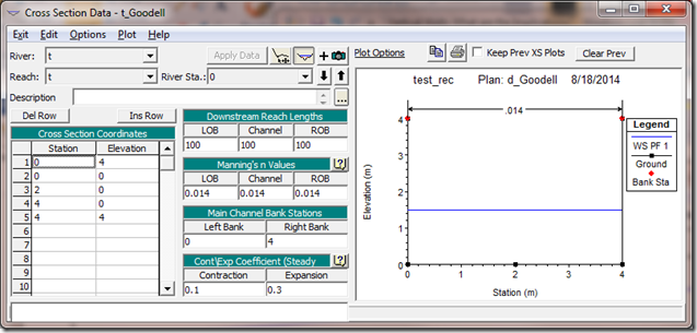
Fortunately, in HEC-RAS, we can just code in the flume as it really is, sharing two elevations for one stationing value as follows:

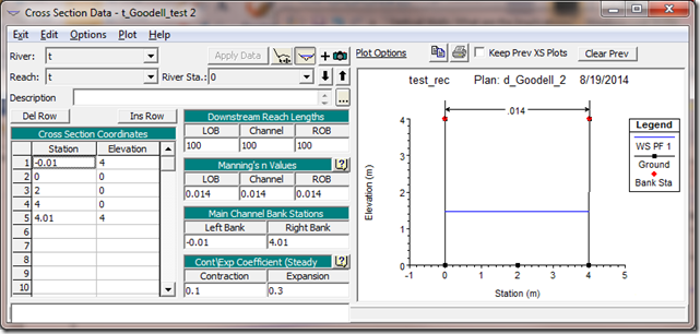
If, for whatever reason, you wanted to keep the same station elevation points as the initial try, you could still get the correct answer by moving the left and right bank stations to the outside points as follows:

The bottom line is the first example above will give you an incorrect normal depth of 1.19 meters. The second two examples give the correct answer of 1.48 meters. Give it a try and see if you can replicate this. More information on conveyance distribution in HEC-RAS and it’s implications can be found in the hydraulic reference manual on page 2-4.
Comments
Pak Peng Aquije
on January 7, 2016Thank you for explaining. How would you input the data if the vertical walls have a different roughness coefficient? Thank you.
Chris Goodell
on January 7, 2016Go with the very last option. Just make sure you put your bank stations at the top like the figure shows. Then use horizontal variation of n values under Options in the cross section editor. If you want to prevent HEC-RAS from compositing your vertical wall n value with your channel bottom n value, then go to Options in the Geometric Data editor and turn off Main Channel Manning's n Value Compositing.
Pak Peng Aquije
on January 7, 2016Thank you for the replay. About "composing vertical", HECRAS has like a "minimum slope criteria" and it is quit high (5H:1V) so It wont start composing if my wall is vertical. But actually that was my problem, because I was playing with that "criteria" and nothing happens.
Well, back to my question, so it would be ok have my bank stations at the top and to use a compound n (lets say shotcrete wall and concrete base?) ? Thank you.
Chris Goodell
on January 8, 2016Actually, it composites for any slope that is steeper than 5H:1V. To your question, yes, that is okay and the correct way to model it. Just make sure you don't composite the main channel n value (unless you want it to).
Unknown
on July 12, 2016Thank you all for having this platform I have just discovered
I am modelling a river with one reach using Hec-Georas and have been stuck with the following 3 errors when running the model:
1) station data contains a wall with zero width, elevation goes up and down/down and up without moving over
2) right bank station must be greater than the left bank station
3) first 2 points of the cross section cannot go up but down is OK: last two points of the cross section cannot go down but up is OK. How best can I address such errors, am a first runner and am desperate of solutions. Please Help…
Tinei Dzvatsva
on July 12, 2016Thank you all for having this platform I have just discovered
I am modelling a river with one reach using Hec-Georas and have been stuck with the following 3 errors when running the model:
1) station data contains a wall with zero width, elevation goes up and down/down and up without moving over
2) right bank station must be greater than the left bank station
3) first 2 points of the cross section cannot go up but down is OK: last two points of the cross section cannot go down but up is OK. How best can I address such errors, am a first runner and am desperate of solutions. Please Help…
Chris Goodell
on July 12, 2016Look at the cross sections identified with those error messages. Then remove or edit your station-elevation pairs so that you are not making the listed violations.
Tinei Dzvatsva
on July 13, 2016Thank you Chris for the response. I have tried editing but the problem is am not sure of how for example to remove the wall or add some width to the wall at the specified points. I have tried deleting the points listed. On the right bank station must be greater than the left bank station error, I have tried using the graphical cross section editor to move the right bank station to the right. The problem am facing is HOW to edit the station elevation pairs to rectify the errors, am just new to the software but am liking it and like I said before its great for having this platform with people like you there to rescue us.May you please elaborate further on how to may be address each error.
Chris Goodell
on July 13, 2016Go to the cross section editor (not graphical cross section editor). Make sure the stationing never decreases in numerical value from top to bottom in the table. Also, make sure you don't have three or more of the same stationing values in sequence. That should do it for the vertical walls. For the bank stations, again go to the cross section editor. Make sure the station for the left bank station is lower in numerical value than the station for the right bank station.
Tinei Dzvatsva
on July 15, 2016Thank you very much Chris, have implemented what you told me and re-ran the model with no more errors. however could not import the xml file in Arcmap successfully because of the "unrecognized projection code value error message" which I am currently trying to address. I worked with Geographic cordinates because my study area switches UTM coordinates betweem three zones:34S, 35S and 36S though are the ones I had initially preferred to work with. Is there anything wrong with using Geographic cordinates. Finally I realised that some of my river stations prior to re-running after I had implemented your solutions had downstream reach lengths less or equal to zero yet HecRas requires a positive value. I ended up populating positive values arbitrarily. Is that permissible and what could be the best approach if NOT? Good Day Chris
Chris Goodell
on July 15, 2016RAS accepts a variety of coordinate systems for projection files, but not geographic (latitude/longitude). You must have a very large study area to span three UTM zones! That being the case, I would suggest picking the most suitable UTM zone, or finding a different cartesian coordinate system that might be more inclusive of your entire project. Regarding reach lengths, you are correct, every cross section (except the downstream cross section of a reach) must have a positive value for reach length. These are not arbitrary values and have a major impact on the results. So you must put in accurate values. These can be determined using flowlines with GeoRAS or you can manually measure them yourself. Make sure all of your flow lines and your stream centerline are drawn in GIS from upstream to downstream. That will avoid getting negative values.
LUIS ANTONIO LEYVA CASTILLO
on March 21, 2019Hola, estoy haciendo un trabajo de la Universidad en Hec Ras, y un en un tramo del canal se ubica una caída de tipo vertical, me podrían decir si es posible modelar la caída vertical en Hec Ras.. gracias.
Chris Goodell
on March 23, 2019Si. Puede usar un “inline structure”.
Boyana Kozhuharova
on June 9, 2020Hello there!
Many thanks in advance for your help! I have just started working with HEC-RAS this month and I’m trying to recreate the 1D Gold Creek project of your colleague Krey Price. I watched his video on it and did everything he did, but then when running the plan I got a similar error to the one of Tinei in this forum.
HEC-RAS Error – Incomplete data, the following errors were found:
Plan file: D:\boyana\project\Brisbane river\Brisbane.p03
Geometry file: D:\boyana\project\Brisbane river\Brisbane.g01
Flow file: D:\boyana\project\Brisbane river\Brisbane.u05
River: “Gold Creek” Reach: “Gold Creek” RS:3004
– The last two points of a cross section cannot go DOWN vertically (going up is OK).
I followed your instructions to see in the Cross Section Editor where my stations are placed and made sure that the last cross section (the last two points) were going from lower elevation to higher, but it still gives me this error, when I try to run it.
Do you have any other suggestions on this topic? Is it really meant the last two points or rather all cross sections should display this pattern of “down to up”?
I thank you again in advance for the help!
Best regards
Chris Goodell
on June 9, 2020Strange. Seems like that should have fixed that error. If you respond with a link to your .g01 file, I can take a look and see if I can figure it out.
Boyana Kozhuharova
on June 9, 2020Thank you for answering so fast!
I will share with you a link to a folder in my Google Drive where you will see both the .g01 file and the .hdf if need be.
https://drive.google.com/drive/folders/15y1SDCxApLozO1kovp0gYfzHai9SeDer?usp=sharing
Best regards
Chris Goodell
on June 9, 2020In the cross section editor, go to River Station 3004. In the Station – elevation table on the left, remove the very last pair of points (1095.9, 72.12). Notice the pair of station elevation points above it is the same stationing, but 0.01 meter higher. This is what is meant by “The last two points of a cross section cannot go DOWN vertically (going up is OK)”. Hope this fixes it for you. -Chris
Boyana Kozhuharova
on June 11, 2020Thank you so so much! It finally worked!
Best regards
Add Your Comment